

Climate Mobility Belongs in Your Comprehensive Plan
When planners hear the phrase climate migration, they may picture coastal retreat, wildfire evacuations, or households relocating hundreds of miles after a disaster.
For cities and counties, however, climate mobility is already an immediate planning concern. It is about whether residents can safely and affordably remain in their homes as heat, flooding, energy costs, and insurance pressures increase. It also asks whether people can reach work, schools, health care, cooling centers, and essential services during disruptive weather—and whether local housing and infrastructure can accommodate population shifts.
In practical terms, climate mobility asks three questions:
Can current residents safely stay?
Can people move safely when conditions become disruptive?
Can the community accommodate future housing and population changes without displacement?
These questions reach across land use, housing, transportation, public health, emergency management, and capital planning. Communities can begin answering them by connecting three tools:
A Community Vulnerability Assessment identifies who and what is at risk—and where.
A Climate Action Plan establishes coordinated strategies for reducing that risk.
A Comprehensive Plan embeds those strategies in long-term land use, housing, infrastructure, and investment decisions.
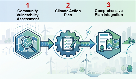
Together, these tools turn climate mobility into a practical planning framework.
1. Ground the Strategy in a Local Vulnerability Assessment
Effective climate mobility planning should begin with a locally specific Community Vulnerability Assessment, or CVA. A strong CVA combines projected climate hazards with information about buildings, infrastructure, natural systems, household conditions, and residents’ ability to prepare for and recover from disruptions.
The goal is to identify places where climate exposure overlaps with limited household resources, fragile infrastructure, housing instability, or barriers to mobility.
A locally focused assessment should ask:
Which public facilities, roads, transit routes, manufactured-housing communities, utility facilities, and emergency access routes are exposed to extreme heat or localized flooding?
Where do stormwater limitations overlap with projected increases in intense precipitation?
Which neighborhoods combine high pavement coverage, limited tree canopy, older housing, and concentrations of heat-sensitive residents?
Where are households experiencing high energy burdens or living in homes without adequate cooling or weatherization?
Which residents may have difficulty reaching shelters, health care, cooling locations, or other essential services without a private vehicle?
Where could resilience investments increase property values and unintentionally displace existing residents?
The CDC/ATSDR Social Vulnerability Index can help identify factors such as poverty, transportation access, and crowded housing, while the U.S. Department of Energy’s LEAD Tool provides local information about energy burden and housing characteristics. Neither should replace local knowledge. Layer census data, utility information, infrastructure records, emergency-response experience, and community input to understand actual conditions.
Planner’s Tip: Avoid relying on a single composite vulnerability score. Use screening tools to identify questions and priority areas, then validate the findings through local data, staff experience, and resident engagement.
2. Use the Climate Action Plan to Turn Risk into Strategy
If the CVA identifies the risks, the Climate Action Plan should explain what the community will do about them.
Climate mobility cannot be assigned to one department. It requires coordinated action among planning, housing, public works, emergency management, public health, parks, utilities, transit providers, and community partners.
For extreme heat and household energy burden, a CAP might prioritize weatherization, heat pumps, expanded tree canopy, resilience hubs, and standards for shade and heat-resilient public spaces.
For localized flooding, it might prioritize stormwater improvements where flood exposure and social vulnerability overlap; expand rain gardens, bioswales, permeable surfaces, and restored wetlands; protect critical access routes; and update drainage standards using projected rather than solely historical conditions.
For housing stability, it might preserve affordable housing near transit and essential services, support resilience improvements without passing unaffordable costs to tenants, expand accessory dwelling units and missing-middle housing, and pair public investments with tenant protections or affordability tools.
For safe access, it might connect cooling centers, resilience hubs, clinics, shelters, and community-serving facilities; ensure residents without cars can reach them; and improve route redundancy so one flooded road or interrupted transit line does not isolate a neighborhood.
The CAP should identify responsible departments, implementation partners, funding sources, timelines, and measurable outcomes. Without those connections, climate mobility may never become a funded program, policy, or capital project.
3. Embed Climate Mobility in the Comprehensive Plan
The comprehensive plan gives climate mobility strategies long-term influence over development, infrastructure, public facilities, and capital investment.
Climate should not be confined to a stand-alone chapter. Relevant goals should also appear in land use, housing, transportation, water resources, parks, public facilities, and implementation chapters.
This is especially timely in the Twin Cities metropolitan region. The Metropolitan Council’s Local Planning Handbook identifies climate as a required comprehensive-plan element. Its adaptation guidance directs communities to describe social, built, and natural-system vulnerabilities related to extreme heat and localized flooding and identify strategies addressing them.
Land Use and Zoning
Use vulnerability findings to guide future land-use maps. Direct housing and mixed-use growth toward lower-risk, transit-connected areas. Limit new critical facilities and high-occupancy uses in areas with significant hazards. Preserve land needed for flood storage, stormwater management, tree canopy, and habitat connectivity.
Housing
Increase the supply and variety of housing in areas with resilient infrastructure and access to transit and services. Preserve existing affordable housing and establish policies for weatherization, cooling, electrification, and flood protection. Anticipate population growth without assuming new demand must displace current residents.
Transportation and Public Facilities
Identify routes connecting residents to shelters, clinics, schools, employment, and cooling locations. Evaluate how heat and flooding affect walking, bicycling, transit, paratransit, and emergency response. Incorporate shade, shelter, seating, and climate-responsive design into transit and pedestrian infrastructure.
Water Resources and Natural Systems
Prioritize stormwater investments where infrastructure limitations and social vulnerability overlap. Protect floodplains, wetlands, drainage corridors, and natural storage areas. Increase tree canopy in neighborhoods with high heat exposure. Integrate green infrastructure into street reconstruction, parks, redevelopment, and public-facility projects.
Implementation and Capital Improvement Programs
Connect comprehensive-plan goals to capital decisions. A project-ranking process could prioritize investments that reduce risk in vulnerable areas, preserve affordable housing, improve access to essential services, address multiple community objectives, or lower long-term energy and emergency-response costs.
Useful performance measures might include:
Residents in priority areas within a safe walking or transit trip of a resilience hub or cooling location.
Affordable homes receiving energy, cooling, or flood-resilience improvements.
Critical facilities with backup power and climate-resilient access.
Tree-canopy gains in neighborhoods with high heat exposure.
Recurrent flooding locations corrected.
Affordable housing preserved near major public resilience investments.
Co-Produce the Plan with the People Most Affected
Maps show where hazards and demographic characteristics overlap, but not how residents experience those conditions.
A route that appears connected in a GIS system may be impassable for a wheelchair user during heavy rain. A cooling center may require two bus transfers. A household may have air conditioning but be unable to afford to operate it. A renter may avoid requesting repairs because of displacement concerns.
These realities require early, sustained, and appropriately compensated engagement. Partner with community-based organizations to hold discussions in trusted locations. Provide translation, interpretation, childcare, transportation, and several ways to participate. Conduct neighborhood mobility audits with older adults, youth, disability advocates, transit riders, and emergency responders. Bring draft maps back to residents for validation rather than presenting them as final conclusions.
Ask questions grounded in lived experience:
Where do you go when your home becomes dangerously hot?
Can you reach that place without a car?
Which streets, intersections, or transit stops become difficult during extreme weather?
What happens when the power goes out?
What improvements would make it easier to remain safely in your home and neighborhood?
Could any proposed investment increase housing costs or displacement pressure?
Climate Mobility Is Good Community Planning
No local government can predict how many people will relocate, when they will move, or which event may change local conditions.
Expanding housing choices, preserving affordability, lowering energy burdens, improving stormwater systems, protecting critical infrastructure, strengthening transit access, increasing tree canopy, and investing in trusted community institutions provide benefits today. They also make communities better prepared for future climate and population changes.
By linking the Community Vulnerability Assessment, Climate Action Plan, and Comprehensive Plan, cities and counties can create a clear path from risk identification to policy, investment, and implementation.
The goal is not simply to manage movement. It is to build communities where residents can safely stay, move when necessary, welcome new neighbors, and continue to belong.
Practitioner Resources
Metropolitan Council Local Planning Handbook: Climate requirements and comprehensive-planning guidance for Twin Cities metropolitan communities.
Metropolitan Council Climate Action Toolkit: Mitigation and adaptation strategies for comprehensive-plan updates.
CDC/ATSDR Social Vulnerability Index: Data for identifying communities that may need additional support before, during, and after hazardous events.
U.S. Department of Energy LEAD Tool: Local information on household energy costs, energy burden, and housing characteristics.
Smart Growth America, Housing for Havens: Strategies for inclusive, resilient growth in communities that may receive climate-related population shifts.
What climate hazard, housing challenge, or planning requirement is currently shaping your community’s comprehensive-plan update?