
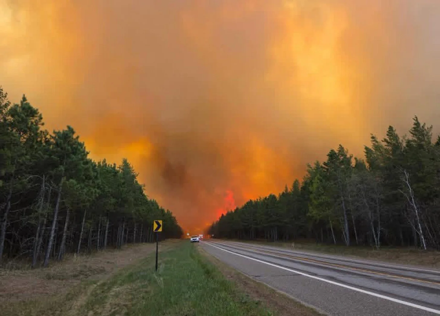
For many Minnesotans, wildfire once seemed like a distant concern—something associated with the western United States, Canada’s remote boreal forests, or southern Europe.
July 2026 has made clear that this is no longer the case.
Lightning-caused fires are still burning across northeastern Minnesota and southern Ontario. Portions of the Boundary Waters Canoe Area Wilderness have been closed, residents have faced evacuation orders, and smoke has produced some of the most extreme air pollution ever measured in Minnesota and the Great Lakes region.
These fires are part of a larger shift. Around the world, hotter conditions, drought, changing precipitation patterns, and accumulated vegetation are contributing to longer fire seasons and a growing risk of large, difficult-to-control fires. Smoke can travel hundreds or thousands of miles, turning a forest fire into a regional public-health emergency.
A Changing Global Fire Environment
Wildfire is a natural part of many ecosystems, but the conditions in which fires occur are changing.
The United States Environmental Protection Agency reports increases in wildfire-season length, fire frequency, and total burned area over recent decades. Higher temperatures, drought, and drier vegetation can increase fire risk, while accumulated trees, brush, and dead vegetation provide additional fuel.
The result is not that every place experiences more fire every year. It is that the conditions capable of producing unusually large, severe, or fast-moving fires are becoming more common.
Europe: Risk Is Expanding Beyond the Mediterranean
Wildfire has traditionally been concentrated in Mediterranean countries such as Spain, Portugal, Italy, Greece, and southern France.
Recent fire seasons, however, have produced increasingly severe extremes and expanded risk farther north. In 2025, fires burned approximately 1.08 million hectares within the European Union, making it the EU’s most destructive wildfire season in the satellite record. By July 22, 2026, another 254,388 hectares had already burned—above the average for that point in the preceding 20 years.
North America: More Land Burning and More Smoke
The changing wildfire environment is especially visible in North America.
EPA data show that total wildfire-burned acreage in the United States has increased since the 1980s, with all ten of the highest-acreage years in the federal indicator record occurring after 2004.
As of late July 2026, more than 4 million acres had burned across the United States, while Canada reported more than 3.7 million hectares burned and hundreds of active fires.
The smoke from these fires spread across the Great Lakes, Midwest, Northeast, and Mid-Atlantic, exposing millions of people to unhealthy or hazardous fine-particle pollution.
July 2026: Major Wildfires in Northeastern Minnesota
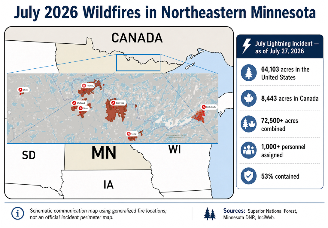
Lightning-caused fires across northeastern Minnesota and southern Ontario burned more than 72,500 combined acres by July 27, 2026, prompting closures, evacuations, and a large multiagency response.
On July 6, a dry thunderstorm produced more than 1,000 lightning strikes across northeastern Minnesota and southern Canada. Dozens of fires were detected in Cook, Lake, and St. Louis counties. Record heat, low humidity, dry vegetation, and the number of simultaneous ignitions allowed several fires to grow rapidly.
As of July 27, the combined July Lightning Incident had burned approximately:
64,103 acres in the United States
8,443 additional acres in Canada
More than 72,500 acres combined
More than 1,000 personnel were assigned to the incident, and the fires collectively were estimated to be 53% contained.
Several large fires remained active, including the Bear Trap, Thumb, Sioux, Little Knife, and Camp fires. Some evacuation areas remained in effect, portions of the Boundary Waters were still closed, and fire restrictions continued across the Superior National Forest and parts of northern Minnesota.
Minnesota’s Most Extreme Smoke Event on Record
Between July 14 and July 17, smoke from the Minnesota and Ontario fires settled across much of Minnesota.
The Minnesota State Climatology Office described the event as the most intense smoke pollution on record in the state and likely Minnesota’s worst and most widespread smoke outbreak in at least 50 years.
A monitoring station in West Duluth recorded an hourly fine-particle concentration of 617.8 micrograms per cubic meter on July 15, apparently breaking Minnesota’s previous hourly record. A Blaine monitor recorded 342.8 micrograms per cubic meter, setting a Twin Cities-area record by a wide margin. Final confirmation remained subject to additional quality review.
Air-quality alerts reached the maroon, or “Hazardous,” AQI category, the highest category used by the official U.S. Air Quality Index. In northeastern Minnesota, residents were advised to avoid outdoor activity and remain indoors because the air was considered hazardous for everyone.
Some real-time sensors showed calculated AQI values of 500 or higher. Because the official EPA AQI scale is capped at 500, values reported above that threshold indicate pollution beyond the top of the standard scale rather than a separate official category.
In practical terms, the public-health message was the same: the air was hazardous for everyone.
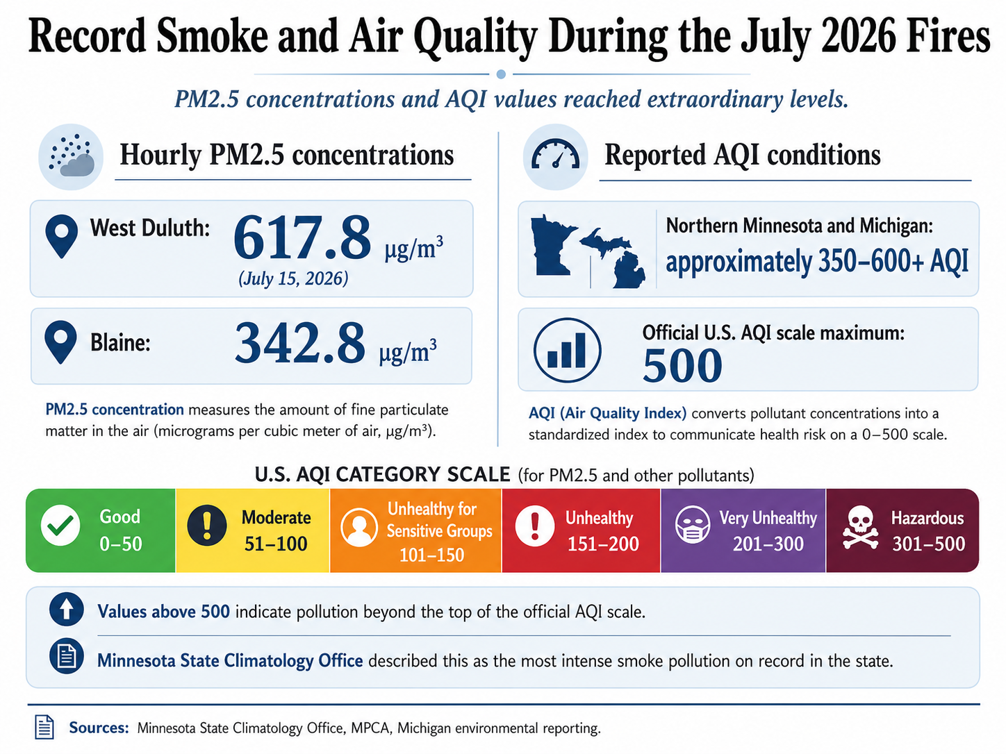
Smoke from the July 2026 fires produced hazardous air quality across Minnesota and Michigan. Some calculated sensor readings reached or exceeded the upper limit of the official U.S. Air Quality Index
Michigan and the Wider Midwest Also Saw Extraordinary Pollution
The smoke spread well beyond Minnesota.
On July 16, the entire state of Michigan was affected by dense smoke from fires in Ontario and northern Minnesota. Reported PM2.5 AQI values across Michigan ranged from approximately 350 to 600, with some short-duration sensors reaching the 600s. Michigan environmental officials described the event as unprecedented and significantly worse than the state’s major smoke events of 2023 and 2025.
Chicago, Minneapolis, Detroit, and other Great Lakes cities ranked among the most polluted major cities in the world during portions of the event. Outdoor activities were canceled or moved indoors, and residents across multiple states were advised to reduce exertion and limit time outside.
Wildfire Is Now a Minnesota Community-Resilience Issue
Minnesota will not experience wildfire in exactly the same way as California, British Columbia, or southern Europe. But July 2026 shows that Minnesota and the Upper Midwest are not insulated from wildfire risk.
Communities may face direct threats to homes and infrastructure, hazardous smoke, outdoor-work disruptions, impacts to tourism and recreation, health risks for vulnerable residents, pressure on emergency services, and effects on forests, wildlife, water resources, and carbon storage.
Wildfire preparedness should therefore be integrated into climate adaptation, comprehensive planning, public-health planning, emergency operations, infrastructure planning, and natural-resource management.
That can include strengthening emergency communication systems, identifying clean-air public spaces, improving building filtration, preparing for outdoor-event disruptions, managing vegetation around vulnerable areas, and helping residents understand what to do during hazardous smoke events.
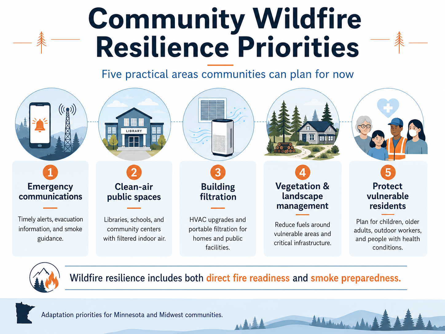
Wildfire resilience includes both direct fire preparedness and planning for smoke, public-health impacts, infrastructure disruptions, and vulnerable populations.
Preparing for Conditions That Historical Experience May Not Predict
The lesson from July is not that every Minnesota summer will look like 2026.
It is that the range of conditions Minnesota communities must be prepared for is changing.
A single dry-lightning event, followed by heat and low humidity, produced dozens of fires, closed portions of one of the nation’s most treasured wilderness areas, required more than 1,000 fire personnel, and generated record-breaking air pollution across Minnesota and Michigan.
Communities cannot eliminate wildfire or prevent smoke from crossing state and international borders. They can, however, plan for these events, protect vulnerable residents, improve public communication, manage landscapes responsibly, and reduce the greenhouse-gas emissions contributing to longer-term climate risk.
For Minnesota and the Midwest, wildfire is no longer just something happening somewhere else.
In July 2026, it arrived at our front door.
Is your community prepared for climate conditions that historical experience may not predict? paleBLUEdot helps local governments assess vulnerabilities, strengthen climate-resilience strategies, and turn emerging risks into practical community action.